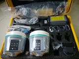
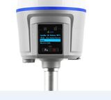
| Prod Model: |
V100 |
| Name And Model: |
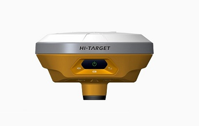
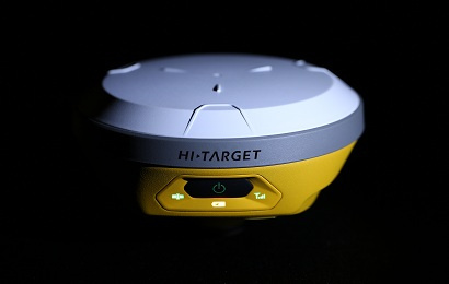
Hi Target V100 |
| Horizontal: |
2.5mm+0.5ppm RMS |
| Vertical: |
5mm+0.5ppm RMS |
| Type: |
GPS Receiver |
| Use: |
Automotive&Hand Held |
| Brand: |
Hi Target |
Product Description
Compact, easy-to-use, network RTK.The V100 is a compact,lightweight and intelligent GNSS RTK Receiver.The built-in whole constellation BD970 OEM board, 4.0 standard dual-mode long-range Bluetooth and NFC module, data collection internet support and Hi-Target Cloud service make this the most convenient and efficient receiver for the network age.
Key features
1) Ultimate compact design
2) BD970 GNSS engine
3) Support GPS, GLONASS, BDS, GALLILEO
Detail advantage functions
1 Multi-constellation tracking
1)220 tracking channels
2)Supports GPS, GLONASS, Galileo,BDS, SBAS
3)NGS approved GNSS antenna
2 Convenient Communication
1)Bluetooth can be connected in seconds based on NFC technology4.0 standard dual-mode long-range Bluetooth, compatible with 2.1 standard Bluetooth
3 Power Battery
1)Powered by high-capacity (6300mAh) Li-ion battery
2)Supports power bank to charge, the battery can be used universally with iHand20 handheld battery
4 Cloud Service
1)Remote Upgrade
2)Remote Register
3)Remote Control
4)Remote Download
5)Cloud Backup
5 Wide Range of Application
V100 can be paired with varieties of handhelds and GIS data collectors, and provide an easy-to-use solution for survey and GIS professionals who need to collect highly accurate data in a variety of applications
You can be informed about product price or be an agent of the product through following the ways:
1. Purchase by telephone, email or filling your desired prices online
2. Fill in your profile online and become one of our partners
Satellite Signals Tracked Simultaneously
220 Channels
GPS : Simultaneous L1C/A, L2C, L2E, L5
GLONASS : Simultaneous L1C/A, L1P, L2C/A (GLONASS M only), L2P
SBAS : Simultaneous L1 C/A, L5
Galileo : Simultaneous L1 BOC, E5A, E5B, E5AltBOCi (Reserved)
BDS : B1, B2
QZSS : L1 C/A, L1 SAIF, L2C, L5
POSITIONING PERFORMANCE
Real Time Kinematic(RTK) Surveying
Horizontal : 8mm+1ppm RMS
Vertical : 15mm+1ppm RMS
Initialization time : Typically < 8 seconds
Initialization reliability : Typically > 99.9%
Code Differential GNSS Positioning
Horizontal : 25cm+1ppm RMS
Vertical : 50cm+1ppm RMS
SBAS : 0.50m Horizontal, 0.85m Vertical
Static and Fast Static GNSS Surveying
Horizontal : 2.5mm+1ppm RMS
Vertical : 5mm+1ppm RMS
Support Stop&Go and PPK
You can be informed about product price or be an agent of the product through following the ways:
1. Purchase by telephone, email or filling your desired prices online
2. Fill in your profile online and become one of our partners
Physical
Dimensions(WxH) : 127.5mm×57mm (5.02inch x 2.24inch)
Weight : 700g (1.54lb) including internal battery
Operating temperature : -40ºCto +65ºC (-40ºF to +149ºF)
Storage temperature : -40ºC to +75ºC(-40ºF to +167ºF)
Humidity : 100%, considering
Water/dustproof : IP67 dustproof, protected from temporary immersion to depth of 2m (6.56ft).
Shock and vibration : Designed to survive a 3m(9.84ft) natural fall onto concrete.
Electrical
Power consumption 3.2W
Rechargeable, removable 3.7V/6300mAh Lithium-ion battery, supports online charging
Power input: 4.5V-5.5V/ 2A DC (USB), 6V-28V/2A DC (5 pin port)
Data storage : 8GB Internal storage
Internal Battery Life
Static 13 hours
RTK Rover (Data collector internet) 10 hours
I/O Interface
1 x mini USB port, for data downloading, power supply and firmware upgrading
1 x 5-pin port, for NMEA output, DC power supply and external devices
Communication
Dual-mode Bluetooth 4.0, compatible with Bluetooth 2.1, 2.4GHz
NFC (Near Field Communication)
Hi-Target/ Pacific Crest ADL Vantage pro external radio (optional)
Data Formats
1Hz positioning output, up to 20Hz
CMR: CMR, CMR+, sCMRx input and output
RTCM: RTCM 2.1, 2.3, 3.0, 3.1, 3.2 input and output
Navigation outputs ASCII: NMEA-0183 GSV, AVR, RMC, HDT, VGK, VHD, ROT, GGK, GGA, GSA, ZDA, VTG, GST, PJT, PJK, BPQ, GLL, GRS, GBS
Navigation outputs binary: GSOF
iDeveloped under a License of the European Union and the European Space Agency.
iiPrecision and reliability may be subject to anomalies due to multipath, obstructions, satellite geometry, and atmospheric conditions.
iiiGPS only and depends on SBAS system performance. FAA WAAS accuracy specifications are <5 m 3DRMS.
Descriptions and Specifications are subject to change without notice
You can be informed about product price or be an agent of the product through following the ways:
1. Purchase by telephone, email or filling your desired prices online
2. Fill in your profile online and become one of our partners
Our company supplys different kinds of products. High quality and favaroble price. We stick to the principle of "quality first, service first, continuous improvement and innovation to meet the customers" for the management and "zero defect, zero complaints" as the quality objective. To perfect our service, we provide the products with good quality at the reasonable price.
Shanghai Galaxy International Trade Co., Ltd is special line in all kind survey instruments.
· Variety Survey Instruments:
Total Station, GPS, Theodolite, Auto Level, Distance Laser Sensor, Tripod, Prism, Prism Pole, Battery, Charger, Data Cable, ect.
· Perfect Technique Service:
We have a strong technique Team: Studying, Researching, Developing and can repair all kind brand Survey Instruments.
· Production Capacity:
We have own factory to produce our brand Total Station, Theodolite, Distance Laser Sensor, ect. OEM can be done.
· The Guarantee of After -Sales Service:
We promise supply the after-Sales Service and let our Customers has no worries about the quality of our products.