Intelligent Rtk GPS Surveying System
| Price: |
US $ 4650-11500/Set |
| Min Order: |
1/Set |
| Pay Type: |
L/C,T/T,D/P,Western Union,Paypal |
| Prod Model: |
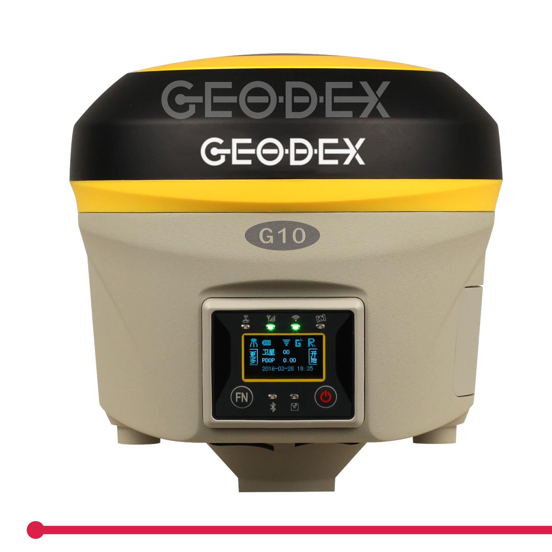
G10 |
| Tracked Signals: |
GPS/Glonass/Galileo/Bds/Sbas |
| Rtk Accuracy: |
Plane: 8mm + 1ppm; Elevation: 15mm + 1ppm |
| Dgps: |
Plane: 0.25m + 1ppm; Elevation: 0.5m + 1ppm |
| Static Accuracy: |
Plane: 2.5mm+1ppm; Elevation: 5mm+1ppm |
| Intelligent Function: |
Tilt Survey, E-Bubble, Voice Guidance |
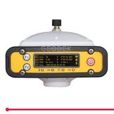
| OLED Screen: |
1.2inch HD OLED Screen, 128*64dpi |
| Radio Power: |
Internal :2W / External :35W |
| Wireless Connection: |
Bluetooth, WiFi |
| Network Communication: |
WCDMA, Support HSDPA+. GPRS, GSM(CDMA EVDO) |
| Differential Format: |
Cmr. Cmr+. Rtcm23. Rtcm3. X |
Product Description
The Most Advanced Intelligent
Full Function High Precision RTK GNSS Receiver
The G10 brings you with technology revolution of the GNSS RTK measurement. Ingenious shell of magnesium alloy, loading with brandnew RTK Intelligent Control Platform, equipped with Electronic Bubble, Tilt Sensor Correction, Web User Interface (UI). Besides, it provides you a brand-new measurement management concept based on iCloud platform.It delivers you with a new RTK Measurement Experience.Technical Specifications:| MODEL | G10 |
| Tracking Capability |
| Number of Channels | 220 Channels |
| Trached Signals | GPS: L1C/A, L1C, L2C, L2E, L5 GLONASS: L1C/A, L1P, L2C/A, L2P, L3 BDS: B1, B2 |
| Galileo: E1, E5A, E5B SBAS: WAAS, ENGOS, GAGAN, MSAS, QZSS |
| Positioning Accuracy |
| Code differential GNSS positioning (DGPS) | Horizontal: ± 0.25 m + 1 ppm RMS Vertical: ± 0.50 m + 1 ppm RMS |
| SBAS differential positioning accuracy: Typically < 5 m |
| Static GNSS surveying | Horizontal: ± 2.5 mm + 0.5 ppm RMS Vertical: ± 5.0 mm + 0.5 ppm RMS |
| Real Time Kinematic surveying (RTK) | Single Baseline < 30km: Horizontal: ± 8 mm + 1 ppm RMS Vertical: ± 15 mm + 1 ppm RMS |
| Network RTK: Horizontal: ± 8 mm + 0.5 ppm RMS Vertical: ± 5 mm + 0.5 ppm RMS |
| Initialization time: Typically < 8 seconds Initialization reliability: Typically > 99.9% |
| Tilt survey (2m GPS pole): 10degree to 30 degree: 10mm to 30mm |
| Hardware Physical |
| Size (W × H) | 14.1cm × 14cm |
| Weight | 1.45kg with battery |
| Material | Magnesium alloy shell |
| Temperature | Operating Temperature: -30ºC ~ +65ºC Storage Temperature: -40ºC ~ +75ºC |
| Humidity | 100%, condensing |
| Dust/Water Protection | IP67 at closing all connector caps. Protected agaist temporary immersion up to 1m depth. |
| Shock and vibration | Designed to survive a 2m natural fall onto concrete |
| Electrical |
| Power | 9 to 22V DC external power input with over-voltage protection |
| Rechargeable | Removable 11.1V, 3.4Ah Lithium-ion smart battery with LED status indicators |
| Input voltage | 100 to 240V AC (50/60Hz) |
| Power consumption | 6.2W in RTK rover mode with internal radio |
| Operating times on single battery | Static mode: 12 hours UHF receive only option: 8 hours |
| UHF receive/transmit option (2.0W): 4.3 hours |
| WCDMA/GPRS receive option: 6 hours |
| Operation system |
| Button | Double buttons and visual operation interface |
| LCD | 1.2inch HD OLED screen, 128 × 64 dpi sunlight readable |
| Voice | iVoice intelligent voice technology provides status and operation voice promptly |
| Communications and Data Storage |
| Internal Radio | Frequency: 410 ~ 470MHz Working range: 3 ~ 5km |
| Transmitting power: 0.5W/2W adjustable |
| External Radio | Frequency: 410 ~ 470MHz Working range: 8 ~ 30km |
| Transmitting power: 5W/35W adjustable |
| Cellular | WCDMA3.5G, GPRS/EDGE (option CDMA2000/EVDO 3G) |
| Bluetooth | Bluetooth2.1 + EDR/Bluetooth 4.0 BLE |
| Wi-Fi | 802.11 b/g/n, accress point mode |
| Data storage | Internal Memory: 4GB External Memory: Micro SD card (Max.32GB) |
| Data Formats | 1Hz positioning output, up to 20Hz |
| CMR, CMR+, RTCM2.3, RTCM3.0, RTCM3.1, RTCM3.2 |
| MSM input and output |
| Web UI | Offers simple configuration, operation, status, and data transfer |
| Accessible via Wi-Fi, Serial, USB, and Bluetooth |
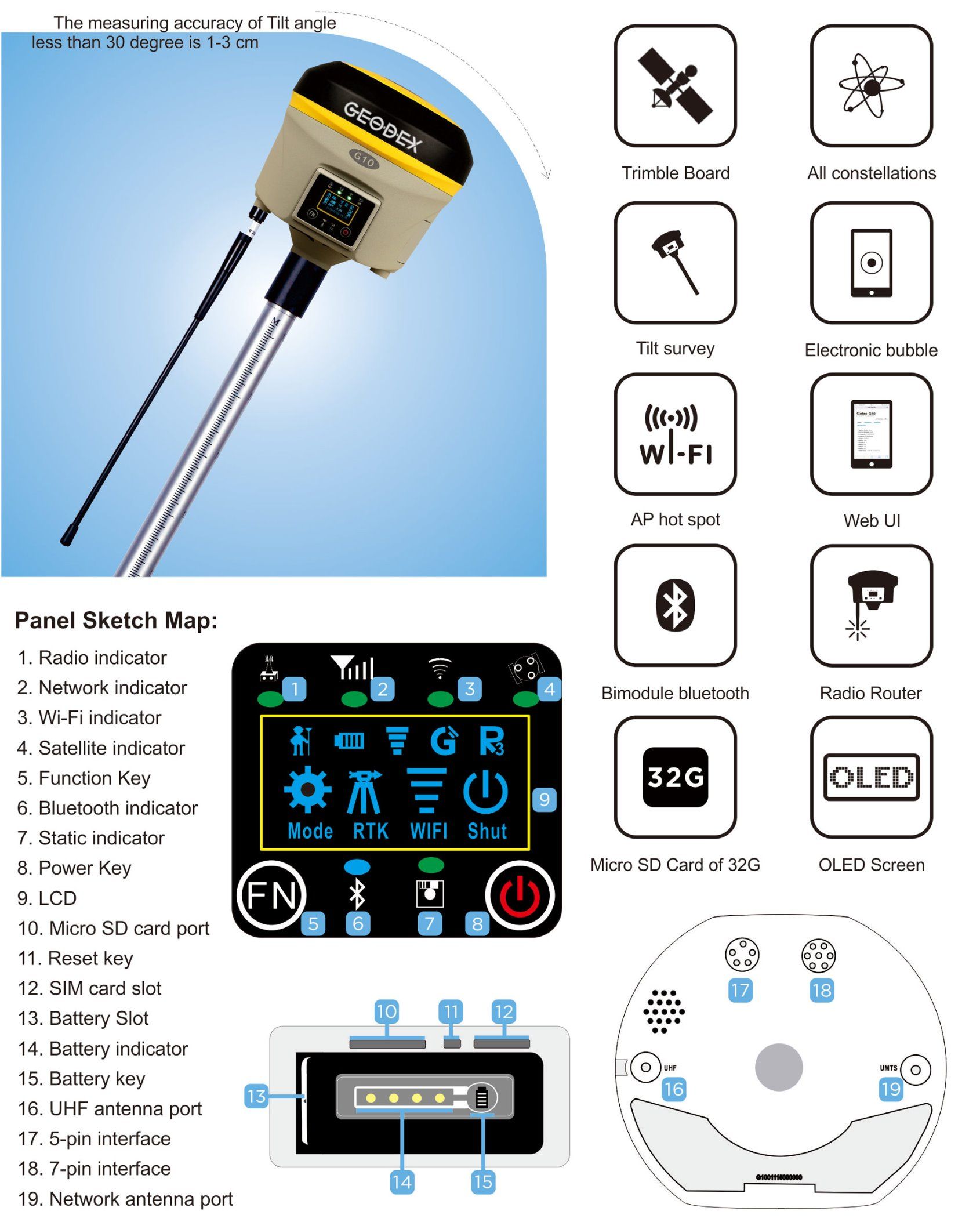
| I/O port |
| GPRS antenna connector/UHF antenna connector DC power input (5-pin)/RS232 and USB port (7-pin) SIM card slot/1 X Micro SD slot |
| Tilt Survey System |
| Built in tilt compensator, correcting coordinates automatically according to the tilt direction and angle of the centering rod |
| Electronic Bubble |
| Controller software display electronic bubble, checking leveling status of the centering rod real time |
| Data cloud service |
| Web page cloud service management platform, supporting online register etc. |
Function Features:
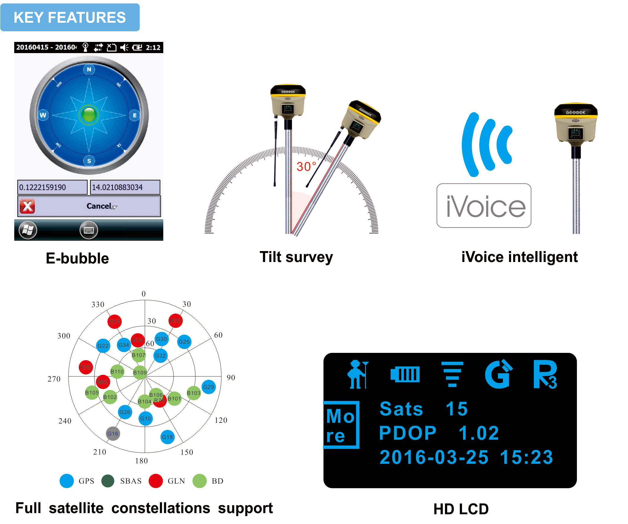 E-bubble: The internal Electronic bubble sensor can display the survey status of the receiver on the controller in real time. You don't even need a leveling bubble on the pole anymore.
Tilt survey: The internal Tilt sensor helps to survey without leveling the receiver, in order to improve survey efficiency. Tilt angle is allowed up to 30 degree. Bulit-in tilt compensator corrects the coordinates according to the direction and tilt angle.
iVoice intelligent: iVoice intelligent voice technology provides status and operation voice promptly, and supports multiple languages.
Full satellite constellations support: Equipped with most advanced GNSS boards,G10 system can track most signals from all kinds of running satellite constellation, especially support B1, B2 singnal from Beidou, also is able to get position result only with Beidou singnal.
HD LCD: 1.2 inch HD OLED colorful LCD supporting multiple language display and it is suitable fo field work with high brightness and low power consumption.
Intelligent data communication Internal radio: Internal radio module is compatible with current radio protocols in the market, also support all kinds of network types to access CORS seamlessly.
Network: Adopting new network program frame, it supports all kinds of network types to access CORS seamlessly 3.5G high speed network and is extendable to 4G.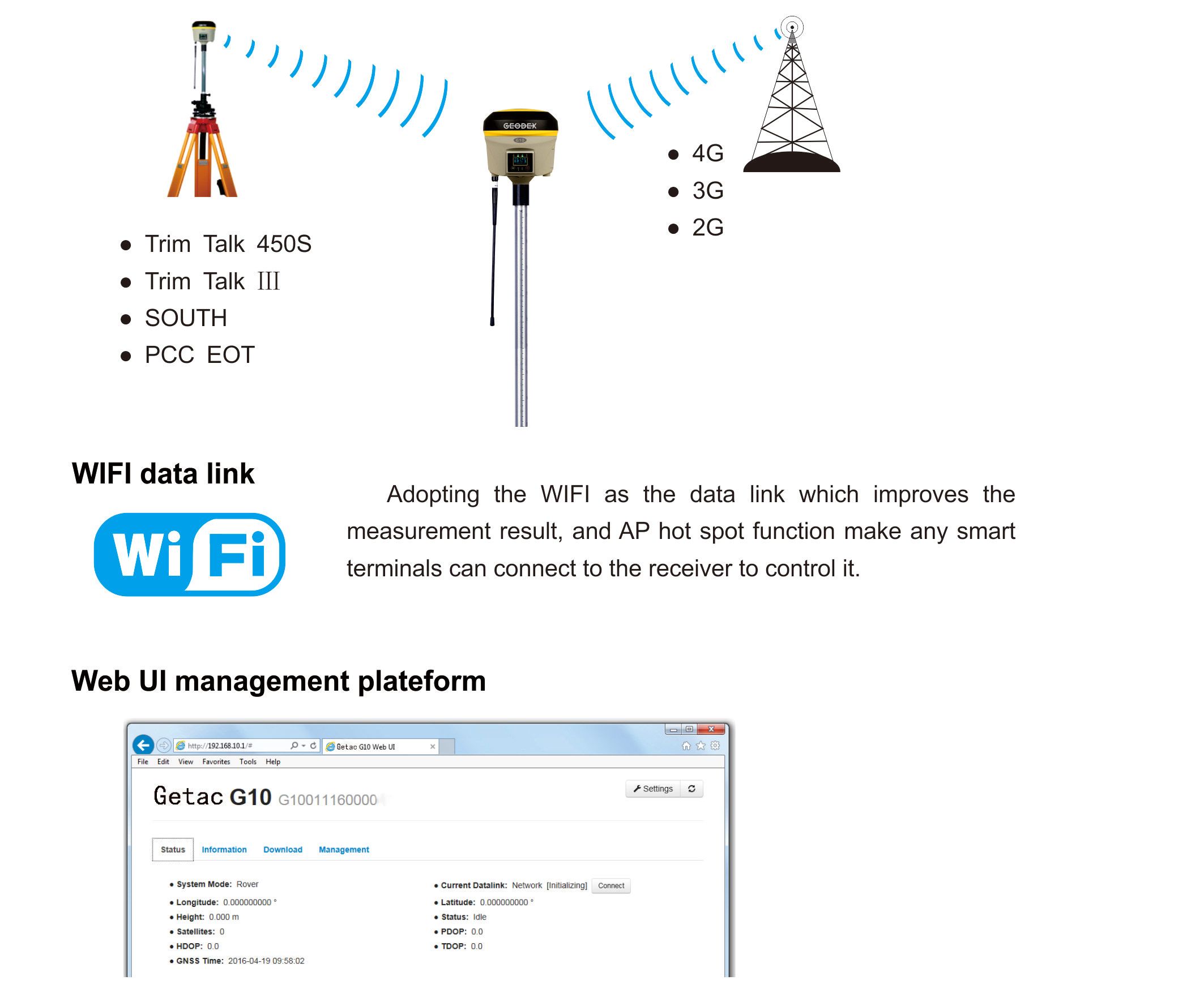 The internal Web UI management platform of G10 supports WIFI mode connection. Users can monitor the receiver status and configure it via the internal Web UI management platform.
Stronger: Magnesium alloy materials create an extremely rugged, compact and light machine body for G10. The anti impact ability, shock absorbing ability and beat dissipation ability are greatly improved. 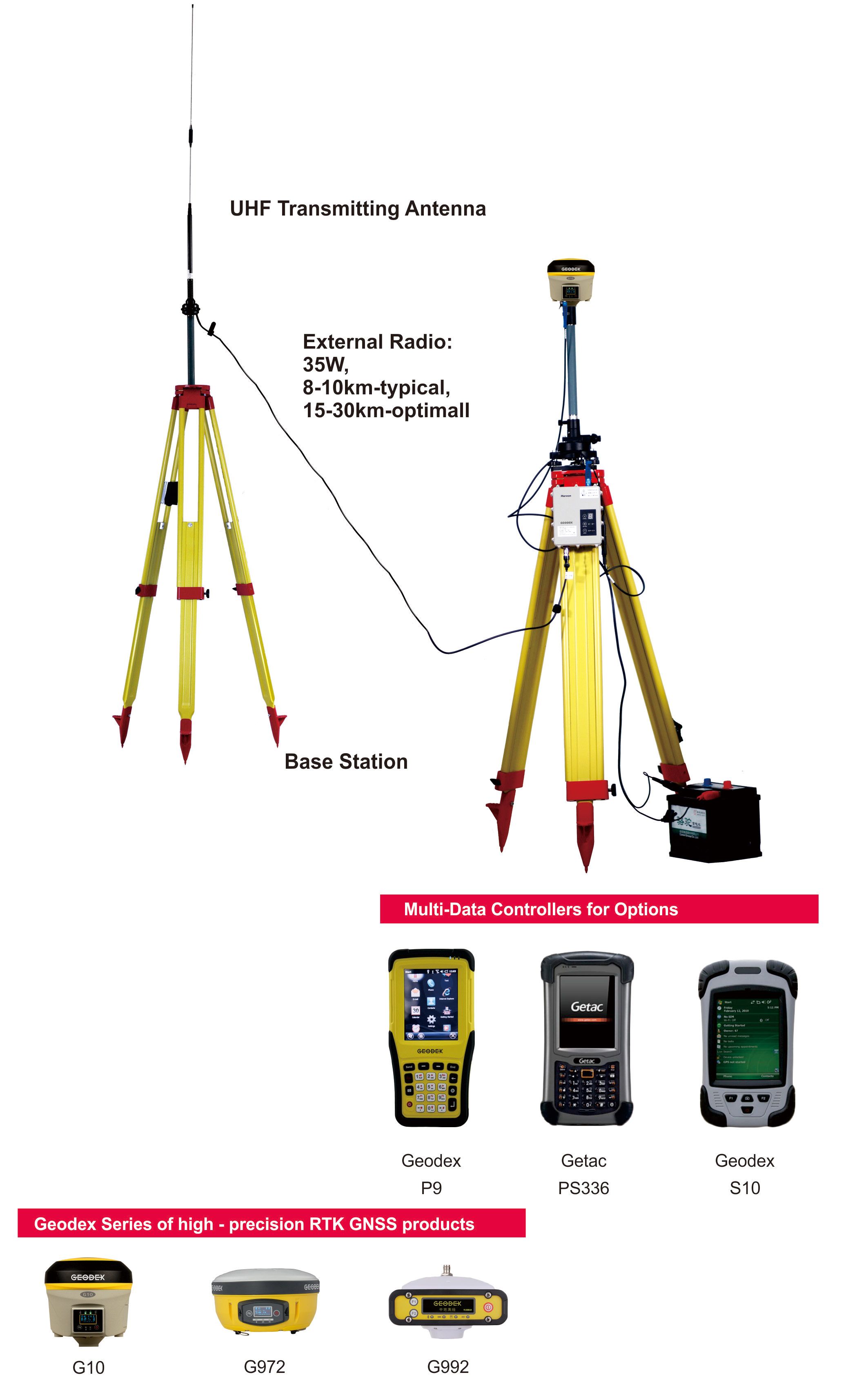 E-Survey Software
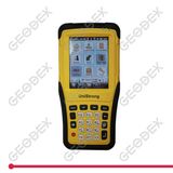
Professional,intuitive and efficient
This E-Survey RTK data controller Field Software is designed & developped by the most professional software R&D engineers team, which brings you a professional, intuitive and efficient measurement of the new experience. The E-Survey software integrates construction survey, power survey, GIS data collecting in one unit. This software is compatible both with Windows Mobile and Android platform, it also supports the smart phone to be used as data controller. 1. Power Survey Line selection, cross measurement, 4-D Data Format output.
2. Road survey Road design, Middle Side Stake Layout, Cross section survey.
3. Base Map Loading Support vector data loading such as DXF, SHP and GCP.
4. GIS collection Support Attribute Data Collecting by Self-Defined data dictionary and export GIS exchange format.
5. Post Processing Software GGO Support to convert the data format into RINEX, which is compatible with AutoCAD and other Drawing & Mapping Software.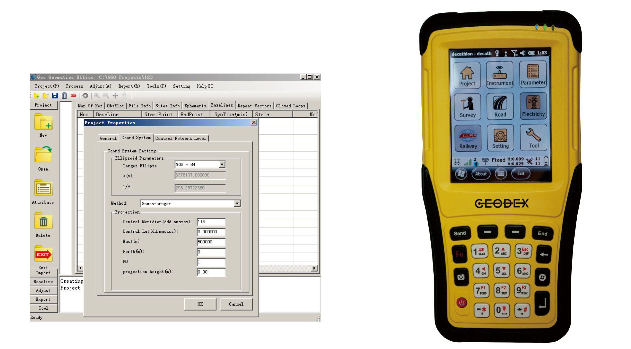
About Us
Geodex is one of the leading worldwide provider of high precision Geographic Surveying & Mapping Equipment, our main products includes RTK GPS, handheld GPS, Total Station, theodolites, automatic levels, laser level and so on.
These kinds of products are widely used for high precision measurement, surveying & mapping works, such as land & housing management, building, road, railway & city infrastructure construction, Topographic, Cadastral, monitoring and mining, hydro & marine surveying projects.
Geodex's office & factories are based in China. Its head office is located in Guangzhou, and main factories are located in Guangzhou & Beijing.
Geodex's main customers are geographic surveying information departments and construction companies, its products are also sold to Colleague & University for teaching uses.
Geodex sells products to many different countries. It has a high market reputation because it not only provides high quality products, but also excellent customer & technical supports.
Mission Statement
Make A Difference by Delivering Surveying Equipment to All Over the World
Our mission is to help our clients to be more competitive and achieve more business success.
Packaging & Shipping
Geodex has excellent performance in providing Oversea Transportation Solutions. Goods would be arranged to send by Express Courier door-to-door delivery service like DHL, FedEx, UPS, TNT and so on or General Air Cargo Service from airport to airport, shipment by ocean (boat), by truck via land transport or special line service forwarder agent appointed by buyers.
About Technical Supports
1) We provide not only high cost-efficiency surveying instruments,
2) but also professional surveying solutions and strong technical supports including maintenance & parts service.
3) Make sure Quality Verified & recalibrated before each shipment.
4) Fast Delivery, stocked in Guangzhou.
5) Professional Export & Import Service.
6) One-year warranty period of surveying equipments.
Contact
Guangzhou Geoland Instrument Co., Ltd.
Add: D5-410, Minjie Squre, Shuixi Road, Huangpu District, Guangzhou, 510530, Guangdong, China
TEL: +86 (0)20-8251 6799 FAX: +86 (0)20-8251 6499
Website: http://www.geodexsurvey.com
------------------------------------------
More >
Other Products with This Manufacturers